Cecret Lake
hikers: Mark and Lecia
distance: 5.3 miles
elevation gain: 1,211 feet
We parked in the parking lot, just before the tollbooth that goes up the canyon.
This is where we started the hike.
Before we went too far we spotted a moose. Other people on the trail were stopped and pointing their cameras so it was easy to know it was there.
There were a lot of wildflowers out but it wasn't the peak of their blooming.
lupine and Indian paintbrush
lupine
wild geranium - sticky purple geranium
Engelmann Aster
Indian paintbrush
After passing the meadow of wildflowers, this is the place to go left if you want to go the the Albion Basin campground area and the Cecret lake trailhead and parking.
Last time we took the utility road to the right. Less crowded, steeper, and further on you need to go thru the trees a short distance to get on the Cecret lake trail.
and saw signs that it is indeed a ski resort.
Here is the beginning of the trail to Cecret Lake. There was lots of photography happening so it wasn't easy to get this picture with no one in it!
There were a few wet areas like this one to cross.
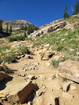
The last part of the hike is the steepest.
But if you keep going you are at the lake! It is beautiful and this time we walked all the way around it. This was our first time to do that!

Then we headed back down again.
Doing the hike from Alta ski resort allows you to see the meadow, adds a couple miles to to the journey, and saves a toll and there is a lot more parking available!


No comments:
Post a Comment