Tuesday, December 7, 2021

July 5, 2021 Capitol Reef

We picked a few hikes to do at Capitol Reef National Park and we probably would have done more, or ones that we haven't done before, if it hadn't been so hot during the day.  A lot of the hikes lack shade, but we found some good hikes and some good shade too, not always combined.  The first hike after we got there was the Hickman Bridge.  Ethan, Mark, and I were on this trip and the three of us were the hikers!


Hickman Bridge

According to the information we picked up at the visitor's center this hike is rated as moderate, is .9 miles one way, of course that means it is nearly 2 miles since you aren't just going to go to the natural bridge and stay, you've got to go back!, and has an elevation gain of 400 feet.  That is why it is in the moderate category.  

This is a hike that we did when we here here a couple of years ago in November, but it is convenient and pretty and was worth repeating.  This is where you start.  It is a well traveled trail, lots of hikers here.


Here is a map of a large area and you can see the trail to the Hickman bridge is a short one!  It is on the top right quadrant of the map.


There are stairs you climb.  And switchbacks that give you that elevation gain.


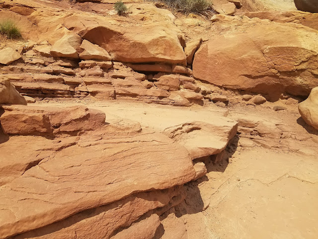
There are interesting rocks, that make you puzzle over the geology of this area.


A survey marker.


It was completely dry while we were there but there had been rain in the previous weeks and we saw this little puddle.


Here is the natural bridge!


And here we are while a nice person took a picture of us.  I don't know why it looks like we are leaning and about to tip over.  optical illusion!  We were just standing there.


A view looking down into the valley.


Some of the vegetation.


I thought this was interesting rock at the base of this mountain.
Here it is  up close!  


Thanks to the CCC (Civilian Conservation Corps) workers 
for all they did back in the day to improve the trails here!


Sunday, October 31, 2021

July 10, 2021 Rocky Mouth Falls

 July 10, 2021

Rocky Mouth Falls

hikers: Ethan, Lecia, Mark

distance: about a mile, since we went a little way on the spur that goes to the bonneville shoreline trail.

elevation gain:  just under 300 feet.


This is such a fun and convenient little hike.  It has been on this blog before and that is because we do it at least once every summer.  

It's easy to get to, easy to hike (and a good hike for kids although we didn't have any with us), a good hike and worthwhile destination.


This is next to the parking lot where you start the hike, just off Wasatch Blvd.  Surprisingly we almost always find a parking spot although we have parked on Wasatch Blvd. before.

First park of the hike is these stairs. At the top is a sign that points you in the right direction to go through a neighborhood.


Walking through the neighborhood to get to the trailhead.

trailhead

First part of the trail.

A sign points the way to go.  If you veer right it takes you to the Bonneville shoreline trail.  On our way back we took this trail for a little ways.


The falls!  There wasn't a lot of water and it doesn't look very exciting but even without water this is a cool place.  Literally.  It is beautiful and lots of rocks and this time we hardly saw any people.  Sometimes it is crowded with people.  There are rocks you can sit on and it is very pleasant.


As I said before, on the way back we took a split off the main trail that leads to the Bonneville shoreline trail.  


We crossed this bridge and headed up the trail a ways.  There were some good views on the trail but we didn't go far before turning around.


When we were driving home we stopped at Hidden Valley Park because we saw this big, beautiful American Flag flying in a nearby canyon. 


I walked over towards the canyon to get a better look.  The flag was so beautiful in the breeze.  Turns out it is only up between the 4th of July and the 24th of July so we were lucky to be over there and see it!  

Little Willow Canyon is a hike we could do another day.  Maybe next Summer in the middle of July so we can see the flag!


Thursday, October 7, 2021

June 26, 2021 Browns Valley Open Space

June 26, 2021

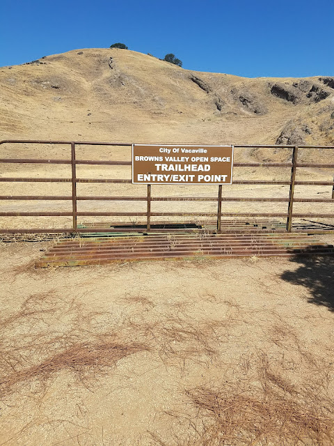
 Browns Valley open space

Vacaville, CA


hikers: Brian, Carol, Mark, Lecia, and Bailey the dog.

distance: we went a couple of miles. We hiked to the top of a hill with a view, and back the same way.


    We spent the night at Brian and Carol's home and the next morning they took us on a hike.  The trailhead was just a couple of blocks from their house so we walked there.  Isn't that great to have hiking so close to home?

They like to bring their grandsons, who are maybe 6 and 8ish, here to hike when they are in town.  


    It looks dry and barren.  Much of it was this time of year with the recent hot weather .  It was a good thing we went in the morning because there isn't a lot of shade.  It wouldn't be pleasant on a hot afternoon.  


                                                 There were a few things growing.


It is uphill.  The further you go the better the view.  


This is Bailey.  Brian borrowed her from his neighbor for the hike. We came to a huge rock and Bailey was ready for a rest.  


There were some trees and this one had a really fun rope swing!


At the top of the hill was a bench,


and a nice view of Vacaville!


Bailey kept the pace nice and slow for the rest of us but on the way down 
it was too much for her.  Brian helped her out.  You can see she is not a small dog. 


Monday, September 13, 2021

 June 25, 2021


Pirate's Cove

near Muir Beach

hikers:  Mark & Lecia

distance:  3.6 miles, out and back.  elevation gain 820 feet

difficulty: I would say it is medium hard because of the distance and it has some steep parts. The short scramble down to the cove is definitely difficult but  but doable. 

This is not a shaded hike. Wear sunscreen. The trail at the beginning is a road and it's pretty steep, and the short scramble to the cove is a very steep and rocky trail.  The rest is up and down the coastal hills. Not a good hike for very young children, but older kids, anyone who can walk 3 and a half miles, would really really like Pirate's Cove!  It is definitely worth it.  You should be aware of the tides as it is a small beach and I don't know what it is like at high tide.

This was a really fun hike because destination was so great!

Pirates' Cove isn't really that far down the coast from Muir beach, but other than by boat the only way to get there is to hike there!  That makes it a secluded and private beach.  But we weren't the only hikers and there were some other people there  besides us.  But is was definitely worth the hike.

We started at the Muir Beach parking lot.  There was a sign that showed us the nearby trails.

We walked across the bridge, as shown on the map, and instead of going down to the beach we turned left to go to the Coastal trail. The entire trail is near the coast but up above the bluff.


This pointed us in the right direction.  


We saw lots of California Poppies, the state flower.


This is the steep part of the trail that is a road. 

 A picture just doesn't capture the angle quite right.  


Not all of the trail is a road.  Much of it is like this.


As I mentioned there are a lot of hills.  You get to the top of one and see that the trail just goes on and on.


There are some beautiful ocean views!  That is what makes it a great hike.


We went over this picturesque bridge.


And had more fantastic ocean views!


Then we saw the trail goes on and on!   My  thought was "oh no we have to go up those stairs!"


But right before the stairs was the turn off to Pirates Cove!  


On the way down.


This is from the bottom looking up.


This little cove is the reward for hiking!  And it was well worth it.  There were a few other people there when we arrived, but we hardly saw them and it felt secluded.


And this was lunch!  We picked up some sandwiches at Panera before we headed to Muir Beach and this vegetarian sandwich and the kitchen sink cookie were excellent choices!


After spending some time at Pirates Cove we scrambled back up the trail to this point where the stairs go towards Tennessee Valley.  We decided to go up that trail a little ways after all.


So up we went.  Mark went further than I did.  
Then we turned around and headed back towards Muir Beach.  
There were other people on the trail but it was not crowded.


I believe that is San Francisco in the background.


And here is Muir Beach.  
We walked down to the beach and looked around before we left. 
We brought our kids to this beach many, many years ago and it has good memories!